- Thumbnail
- Resource ID
- b527816a-f900-11eb-b0f8-0242ac120002
- Title
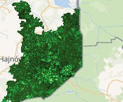
- NDVI rok 2017 Puszcza Białowieska | NDVI year 2017 Bialowieza Forest (Sentinel 2)
- Date
- Aug. 9, 2021, 10:58 a.m., Publication
- Abstract
- Warstwa rastrowa przedstawiająca znormalizowany różnicowy wskaźnik wegetacji (NDVI) w roku 2017 na terenie Puszczy Białowieskiej. Wskaźnik opracowany na podstawie obrazów satelitarnych z misji Sentinel 2 z sezonu letniego (czerwiec-wrzesień).
Raster layer presenting normalized difference vegetation index (NDVI) from year 2017 in Bialoweiza Forest. NDVI developed on satellite imagery from Sentinel 2 from summer season (June-September).
- Edition
- --
- Responsible
- beata_bramorska
- Point of Contact
- Bramorska
- bbramorska@ibs.bialowieza.pl
- Purpose
- Określenie kondycji roślinności i drzew w Puszczy Białowieskiej przed i po inwazji kornika drukarza.
Determining condition of vegetation and trees in Bialowieza Forest before and after the invasion of bark beetle.
- Maintenance Frequency
- None
- Type
- grid
- Restrictions
- None
- License
- Attribution 4.0 International
- Language
- eng
- Temporal Extent
- Start
- --
- End
- --
- Supplemental Information
- Nie podano informacji
- Data Quality
- Zdjęcia satelitarne pobrane od Sentinel Hub (https://www.sentinel-hub.com/)
Satellite imagery downloaded from Sentinel Hub (https://www.sentinel-hub.com/)
- Extent
-
- x0: 23.499911865000000
- x1: 23.939582519000000
- y0: 52.589119661000000
- y1: 52.928831279000000
- Spatial Reference System Identifier
- EPSG:4326
- Keywords
- no keywords
- Category
- Imagery Base Maps Earth Cover
- Regions
-
Poland